
Friday, November 27, 2020
Sunday, August 30, 2020
MODERN TURKEY - AN ETHNIC MIX OF TURKS, GREEKS, PERSIANS AND MANY OTHERS

In the 11th century, Turks began appearing at the edges of Asia Minor (Anatolia), which was then controlled by the Greeks. Many of the Turks were mercenaries in the employ of local Arab and Persian rulers to the east of the Byzantine Empire and Armenia, the dominant states in Asia Minor. In 1037, the Seljuk Empire, a Turkic state, was founded northeast of Iran in Central Asia and quickly overran much of Persia, Iraq, and the Levant. By the 1060s, the Seljuk Empire bordered Byzantine Asia Minor. It should be noted that the Turks were a minority, ruling a Persian, Arab, and Kurdish majority.
The main strategic threat to the Turks was the Fatimid Caliphate based in Egypt. The Fatimids were Ismaili Shia and ruled over Jerusalem and Mecca at that time while the Turks upheld Sunni Islam. The Sunni Caliph in Baghdad was their puppet. By this time, the Caliph had ceased to exercise any political role while the Seljuk sultans held the reigns of power. As was the case of many empires, many problems arose due to the conflicts between nomadic rulers and a sedentary population. Thus, many of the Turkic tribes under Seljuk rule actually posed a problem for the Seljuks since they were restless and sometimes raided settled populations ruled by the Seljuks. As a result, many of the Turkic tribes and families were placed on the frontiers of the Seljuk Empire, including on the frontier of the Byzantine Empire. Turkish raids into Asia Minor commenced, greatly annoying the Byzantines.
The first of the Turkic states in the region was the Ghaznavid Empire, established in the last years of the tenth century. Their dominance was curtailed, however, when large-scale Turkic migrations brought in two new groups of Turks in the east the Qarakhanids and the west the Seljuks who conquered the Ghaznavid territory of Khorazm (also spelled Khorezm and Khwarazm).>
In 1045, the Byzantines conquered Armenia. Their frontier with the Seljuks was not particularly strong or pacified as a result of the intermittent warfare there. Additionally, many Armenians did not like the Byzantines and did not help them resist the Turkish raids. Eventually, by 1071, the Byzantines, exasperated at constant Turkish raiding, decided to move a large army to their borders to eliminate the Turkish threat once and for all. Unfortunately, this was not a particularly good idea, because their strength lay in manning border forts against lightly armed tribal warriors. By attempting to fight a pitched battle, they also risked total defeat.
Furthermore, the Seljuk Turks did not want to antagonize the Byzantines. Their state apparatus was directed against Egypt; it was only tribes that were barely under central Seljuk control that were raiding the Byzantines. Romanus IV Diogenes, the Byzantine Emperor, created a previously non-existent threat for the Seljuks by moving some 40,000 troops to his eastern border, thus alerting the Seljuk Sultan Alp Arslan to the threat from Asia Minor. Thus, the Byzantines, by diverting the Turks’ attention from Egypt, brought a Turkic army to Asia Minor from Persia and Central Asia.
 The first people known to have occupied Central Asia were nomads who arrived from the northern grasslands of what is now Uzbekistan sometime in the first millennium B.C. They began to build an extensive irrigation system along the rivers of the region. In time cities such as Bukhara and Samarkand began to appear as centers of government and culture. By the fifth century B.C., the Bactrian, Soghdian, and Tokharian states dominated the region. As te silk route these settlements took advantage of this commerce by becoming centers of trade and in time became known as Mawarannahr (a name given the region after the Arab conquest) >
The wealth of Mawarannahr was a constant magnet for invasions and numerous intraregional wars were fought in Mawarannahr. Alexander the Great conquered the region in 328 B.C., bringing it briefly under the control of his Macedonian Empire. In the same centuries, however, the region also was an important center of intellectual life and religion. Until the first centuries after Christ, the dominant religion in the region was Zoroastrianism, but Buddhism, Manichaeism, and even Christianity also attracted followers. The conquest of Central Asia by Islamic Arabs, which was completed in the eighth century A.D., brought to the region a new religion and culture that continue to be dominant. The Arabs first invaded Mawarannahr in the middle of the seventh century through sporadic raids during their conquest of Persia.
The Arabs were led by a brilliant general, Qutaybah ibn Muslim, and were highly motivated by the desire to spread their new faith (the official beginning of which was in A.D. 622). The new religion brought by the Arabs spread gradually with the destiny of Central Asia as an Islamic region not being firmly established until the Arab victory over the Chinese armies in 750 in a battle at the Talas River.>
Under Arab rule, Central Asia retained much of its character, remaining an important center of culture and trade for centuries after the Arab conquest. However, until the tenth century the language of government, literature, and commerce was Arabic. Mawarannahr continued to be an important political player in regional affairs, supporting the Abbasid Caliphate in its struggle against the then-ruling Umayyad Caliphate.>
During the height of the Abbasid Caliphate in the eighth and the ninth centuries, Central Asia and Mawarannahr experienced a truly golden age. Bukhoro became one of the leading centers of learning, culture, and art in the Muslim world, its magnificence rivaling contemporaneous cultural centers such as Baghdad, Cairo, and Cordoba. Many of the greatest historians, scientists, and geographers in the history of Islamic culture were natives of the region. As the Abbasid Caliphate began to weaken and local Islamic states emerged as the rulers of Central Asia. the Persian language began to come intp the region as the language of literature and government. Under the Samanids and the Buyids, the rich culture of Mawarannahr continued to flourish.>
The first people known to have occupied Central Asia were nomads who arrived from the northern grasslands of what is now Uzbekistan sometime in the first millennium B.C. They began to build an extensive irrigation system along the rivers of the region. In time cities such as Bukhara and Samarkand began to appear as centers of government and culture. By the fifth century B.C., the Bactrian, Soghdian, and Tokharian states dominated the region. As te silk route these settlements took advantage of this commerce by becoming centers of trade and in time became known as Mawarannahr (a name given the region after the Arab conquest) >
The wealth of Mawarannahr was a constant magnet for invasions and numerous intraregional wars were fought in Mawarannahr. Alexander the Great conquered the region in 328 B.C., bringing it briefly under the control of his Macedonian Empire. In the same centuries, however, the region also was an important center of intellectual life and religion. Until the first centuries after Christ, the dominant religion in the region was Zoroastrianism, but Buddhism, Manichaeism, and even Christianity also attracted followers. The conquest of Central Asia by Islamic Arabs, which was completed in the eighth century A.D., brought to the region a new religion and culture that continue to be dominant. The Arabs first invaded Mawarannahr in the middle of the seventh century through sporadic raids during their conquest of Persia.
The Arabs were led by a brilliant general, Qutaybah ibn Muslim, and were highly motivated by the desire to spread their new faith (the official beginning of which was in A.D. 622). The new religion brought by the Arabs spread gradually with the destiny of Central Asia as an Islamic region not being firmly established until the Arab victory over the Chinese armies in 750 in a battle at the Talas River.>
Under Arab rule, Central Asia retained much of its character, remaining an important center of culture and trade for centuries after the Arab conquest. However, until the tenth century the language of government, literature, and commerce was Arabic. Mawarannahr continued to be an important political player in regional affairs, supporting the Abbasid Caliphate in its struggle against the then-ruling Umayyad Caliphate.>
During the height of the Abbasid Caliphate in the eighth and the ninth centuries, Central Asia and Mawarannahr experienced a truly golden age. Bukhoro became one of the leading centers of learning, culture, and art in the Muslim world, its magnificence rivaling contemporaneous cultural centers such as Baghdad, Cairo, and Cordoba. Many of the greatest historians, scientists, and geographers in the history of Islamic culture were natives of the region. As the Abbasid Caliphate began to weaken and local Islamic states emerged as the rulers of Central Asia. the Persian language began to come intp the region as the language of literature and government. Under the Samanids and the Buyids, the rich culture of Mawarannahr continued to flourish.>
From the fifth to the ninth century AD Turkic tribes who lived in the great grasslands stretching from Mongolia to the Caspian Sea started to move permanently into the region. In the late tenth century, as the Samanids began to lose control of Mawarannahr and Turks started to come to positions of power eventually they established their own states. With the emergence of a Turkic ruling group in the region, other Turkic tribes began to migrate to Mawarannahr.>
The Seljuk and Byzantine armies met at Manzikert in eastern Turkey, where the Byzantines were crushed. This is arguably one of the most decisive battles in history, as it resulted in the eventual establishment of Turkish power in Asia Minor. It was likely that the battle was lost by the Byzantines due to treachery, because units commanded by generals belonging to alternative court factions in Constantinople simply never showed up for the battle, despite being in the vicinity, and returned home afterwards.
Sultan Alp Arslan captured Emperor Diogenes and and offered him generous terms before sending him home. However shortly afterwards, the Byzantine empire suffered a civil war between Diogenes and other contenders for the throne and several generals broke his treaty with the Turks. This left Asia Minor devoid of soldiers and gave the Turks good reason to occupy it. By 1081, they were across the Bosphorus Straits from Constantinople. Although the Byzantines and Crusaders later recovered some territory in Asia Minor, from then on, the majority of the region remained under Turkish control.
But groups of Turks ruled over many states in the Middle East and South Asia at this point in time. Why did they become the majority in Turkey? After the Seljuk victory, many Turks poured into Asia Minor, establishing little statelets, and ruling over the native population. Following the subsequent Mongol invasions, even more poured in, fleeing from their former lands in Persia and Central Asia. Unlike in many other cases, where a dominant minority eventually became assimilated into the majority population, because of the unstable, chaotic frontier situation, the Turks did not assimilate into the population. Indeed, many locals (ethnic Greeks and Armenians) attached themselves to Turkish warlords for protection as clients. This client-patron relationship spread out over many bands and tribes across Asia Minor and ensured that the majority of the population assimilated into the Turkish religion (Islam), language, and culture instead of vice versa.
This is a cultural process known as elite dominance, wherein a minority imposes its culture on the majority. The Turkification of Asia Minor is evident in the fact that genetically, the majority of today’s Turks are most closely related to Greeks and Armenians rather than Central Asian Turkic peoples, like the Uzbeks and Kazakhs. Thus, while the Turkic culture dominated in Asia Minor, the Turks themselves quickly merged genetically into the native population. Genetic studies show that around 15 percent of the Turkish genetic mixture derives from Central Asia.
Asia Minor was the most populous part of the Byzantine Empire, its heartland. Without it, the empire simply didn’t have enough resources to compete in the long run. Turkification was also helped by the fact that the Greeks were of a different religion than the Turks. Greeks converting to Islam would adopt Turkish language. Furthermore, in the later Ottoman Empire, the Turkish language prevailed at the official level, and not local languages. As a result of all these factors, densely populated Asia Minor became the region of the world with the largest concentration of Turkic-speaking peoples, far away from their original homeland in Central Asia.
ED: https://thediplomat.com/2016/06/the-epic-story-of-how-the-turks-migrated-from-central-asia-to-turkey/
Turkification of Mawarannahr

Tuesday, August 25, 2020
Scythia

The most detailed western description is by the"Father of History”, Herodotus, who referred to the “Scythian's” as Sacae and said their own name for themselves was "Scoloti" they were nomads, wandering from place to place in search of the most convenient land for farming. They held horses with especially high esteem. They were most famous for galloping on a horse at full speed while shooting bows, a skill particularly useful in warfare.
The Scythian warrior spirit led them to become an archetype for the Greek valiant half-man and half-horse centaur. Their invasions into distant nations resulted not only in spoils, but also in the accumulation of a wealth of knowledge regarding different cultures that they brought back with themselves.The Scythians were not only talented in warfare, especially cavalry, they were also developed an outstanding art called “beast (or animal) style”, which is characterized by the flowing movements of beasts of prey, some mythical like griffins, and herbivores like the horses they loved and the fierce struggle between them.
Women were valued just as equally as men in Scythian society, and their civilization saw great women leaders in international affairs. For example, when the Persians invaded the territory of the Massagetae Scythian's in 530 BCE (now part of todays Uzbekistan and Kazakhstan) Tomyris, the Scythian queen leading her army defeated the Persians. In one of the most famous stories of antiquity, Tomyris ordered the head of the captured Cyrus the Great, the Persian King, to be cut off and placed into a wine skin filled with his blood in revenge for the death of her son in a prior battle.
The nearly continuous war between the Scythia's and the Persians eventually resulted in the partial alliance of two groups. In 518 BCE Persians set their troops against the Scythian's again, with Persian king Darius I leading his army. The Persian troops were intimidated by the valiant Scythian cavalry, which forced the panic-stricken Persians to flee. As a result of a prolonged battle with the Persians, a part of the Scythian's forces were defeated, and they were forced to provide cavalry for the Persian army. In the Battle of Marathon (490 BCE) the Scythian's fought on the side of the Persians, previously an enemy, now an ally, against the Greeks. The records of Herodotus survived to tell of the bravery of the Scythians and their alliance with the Persian King Xerxes I (the son of Darius I) against the Greeks in the Battle of Plataea (479 BCE). The land of the Scythian's also drew the attention of Alexander the Great. He led a war to crush the Scythian's in the Jaxartes River region, known today as Syr-Darya, in around 329 BCE. He founded his ninth city, Alexandria Eskhate (“Farthest Alexandria”), at the banks of the Syr-Darya River now in southern Kazakhstan.
Many of the customs, traditions, and language of the Karakalpaks are deeply rooted back to the Scythians.According to historical sources, Saka people lived in Karakalpakstan back in the Neolithic Age. The gravestones tombs of Darius I, dating back to the 5th century BC show that the territory around the Aral Sea and Syrdarya were was occupied by the “Saka tigraxauda” (Scythians with pointy hats").
From the 2nd century BCE to the 6th centuries ACE Turkic tribes migrated from the territory of the Altay and Siberia. An assimilation of the indigenous and nomadic Turkic Saka population resulted in a new ethnic group known as Pechenegs. These tribes formed the basis of the formation of ethnic Karakalpaks and Kazakh hordes. The very word 'karakalpak "means " black hats "and refers to the fact that Karakalpaks wore hats from the black sheep's wool.
Friday, August 21, 2020
Big Guldursun
Big Guldursun is located 35 km east of the district center Boston (Ellik-kala district) and 20 km east of the Beruni district. The monument was first excavated from 1937-40 by Y.G.Gulomov and O.T.Dospanov from 1987 untill 1995. Subsequently, a number of numerous articles and a separate book called “Ayemgi Guldursun qalasi” were published. (Dospanov, 1993.)
The monument is one of the largest border fortresses of Ancient Khorezm Empire during IV-I centuries BC., I-VIII AD., and IX-XIV AD. The outer walls were built on the basis of a desolate ancient fortress once conquered by the Arab troops. It is has a form of a rectangle with a total area of 350х230 meters, strictly oriented with corners to the cardinal points. There is a preserved medieval gate of a semi-oval shape in the middle of the south-eastern wall.
The early antique walls were made of raw bricks measuring 40х40х10- 11 cm, stacked on the lower pakhsa blocks. The walls have survived to a height of 15 meters. The inner parts of the walls are medieval, made of bricks of 24х24х5cm and are closely attached to the ancient walls.
During the rebuilding of the fortresses in the time of Khorezmshalhs’ reign, the inner part of the walls of the ancient shooting gallery was demolished. At present, the interior of the ancient walls has preserved traces of rifle loopholes arranged in two rows in a checkerboard pattern. In some places in the pakhsa wall, you can see the clogged, high-altitude arched passages.
The fortress was reinforced by the construction of a pretented barrier with a second row of outrigger towers flanking the approach to the wall, and for this reason they form a so-called “gateway structure” along the entire diameter of semicircular (semi-oval) planes. Excavations and research have shown that the fortress played a purely strategic role and was of great importance in the defense of the head structures of the ancient Gaukhare canal.
During the study of the monument, a deep pit was dug in the inner part, up to 14 meters deep. The analysis and the materials revealed showed that the inner part of the monument was intensively settled down at all times of its existence.
The monument is very interesting architecturally. The “kaptar khana” (room for keeping pigeons) is perfectly preserved in the inner eastern wall. In the scientific literature, it has been written about such "dovecotes" on some medieval monuments in this area.
And also, this information gives reason to assume that carrier pigeons were used to maintain connections between fortresses, cities and individual regions. For this reason, it is no coincidence that a special room was allocated for keeping pigeons, consisting of special niches, deepened in several rows, arranged between the shooting gallery of the eastern wall.
Its eastern and southern corner towers, which were used in the Middle Ages as a warehouse for storing cotton seeds, are of no less architectural and material interest. For proper preservation of seeds on the floor, special “air vents” were used - ventilation holes on the floor, which could actively ventilate the stored seeds.
Saturday, July 18, 2020

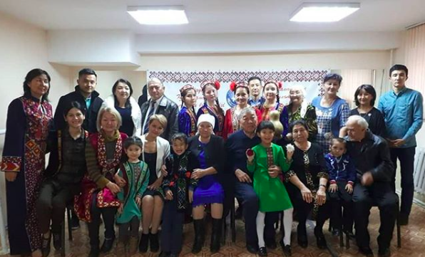
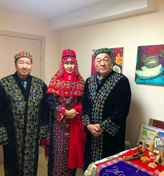
Modern day Karakalpaks living in Kazakhstan
Karakalpaks’ unique culture worth celebrating and preserving in Kazakhstan, says community leader

Tazabike Saliyeva and community members
The Karakalpaks, an ethnic group native to Karakalpakstan in northwestern Uzbekistan, number approximately 620,000 worldwide, 56,000 of which reside in Kazakhstan. The group settled on the Amu Darya river in the 18th century and may also be found in significant numbers in Russia and Turkmenistan. Their name comes from the words kara (black) and kalpak (hat).
Kazakhstan’s Karakalpak community began to develop in its first years of independence. Twenty-six years ago, the Karakalpak association Alayar Zholy was established in the Mangyshlak region. Later, similar associations emerged in Almaty – Bes Kala and Amiyu Zhahasy, Atyrau – Yedil Zhaiyk and Shymkent – Amiyu Sheshekleri.
“The Karakalpak ethno-cultural association Zhaikhun was established in Astana Dec. 9, 2016. Since then, we have been actively participating in all events held by the Assembly of the People of Kazakhstan in the capital,” said Saliyeva.
Tazabike Saliyeva and community members
The Karakalpaks’ language, customs and material culture are similar to other Central Asian groups, particularly that of the Kazakhs. The group uniquely preserves its rich folklore through oral folk art, with many tales and epics set to music. Interestingly, it is dance that brought the community and its leader together in Astana.
“As a choreographer, I have worked with many national centres in the capacity of a dance director. I was sad to discover that, among these centres, there was not a single Karakalpak centre showcasing the group’s rich culture, history, customs and literary heritage. For instance, 156 volumes of Karakalpak oral folk art have been preserved. We thus decided to create our own centre, the Karakalpak ethno-cultural association Zhaikhun,” said Saliyeva.
“The centre actively participates in charity, dance, fashion and music events” and seeks to expand its activities, she noted.
Tazabike Saliyeva and community members
“We aim to find as many representatives of the Karakalpak nation as possible and help them preserve their language, customs and culture. In my opinion, this aim is pursued by every association in the Assembly of the People of Kazakhstan,” she said.
https://astanatimes.com/2018/11/karakalpaks-unique-culture-worth-celebrating-and-preserving-in-kazakhstan-says-community-leader/
Wednesday, July 8, 2020
Jalal ad-Din Mingburnu, the last Khwarazmian Shah .
Jalal ad-Din Mingburnu
His full name was Jalal ad-Dunya wa ad-Din Abul-Muzaffar Manguberdi ibn Muhammad. He was better known as Jalal ad-Din Mingburnu or Jalal ad-Din Khwarazmshah. The son of Shah Ala ad-Din Muhammad II, the man responsible for causing the Mongol invasion of the Khwarazmian Empire.
The newly formed Mongol Empire wanted to trade with the wealthy Khwarazmians and Shah Muhammad II agreed. However the peace was not to last. Soon after a Mongol trading caravan was arrested by a Khwarazmian governor. Genghis Khan sent three messengers to Muhammad II himself, demanding the immediate release of the trading caravan. The Shah had the messengers beheaded. He then ordered the execution of the trading caravan. This resulted in the Mongol invasion of Khwarazmian and the fall of this great empire.

The Khwarezmian Empire at it’s greatest extent 1n 1220 (800 years ago).
The Mongols began their invasion in 1219 and in just over a year the empire was now under Mongol control. Shah Muhammad II fled westwards to a barren island in the Caspian Sea where it is said he died of thirst in 1220.
The fate of the empire now rested in the hands of the young Sultan, Jalal ad-Din Mingburnu, who was only 20 years old at the time. Jalal ad-Din and members of the army (who had survived the onslaught) were forced to flee southwards towards the Hindu Kush. Here he made new alliances with the Afghans and swelled his army to 60,000 men.
The two armies would meet in the Battle of Parwan in 1221 naer modern day Kabul. The Mongol general, Shigi Qutugu, was extremely overconfident as the Mongols had very easily defeated the Khwarezmians in every single battle. He did not initially realize that his army which numbered around 30,000–40,000 was outnumbered. The valley was ill-suited for cavalry. Still confident the Mongols chose to face Jalal ad-Din in direct battle. Over half of the Mongol army was killed in battle and the other was forced to retreat. The image of invincibility that the Mongols had created for themselves was shattered. It was the first time the Mongols had ever been beaten.
Genghis Khan began once again to gather the Mongol army and again face off against the young Sultan. Unfortunately for Jalal ad-Din a disagreement with the Afghans (over a horse belonging to the Mongol General) resulted in tensions with his new allies. Soon he lost the Afghan support altogether. Jalal ad-Din decided to flee eastwards towards the Indus with his army of about 20,000 men and thousands of Khwarezmian refugees. Genghis Khan realising the young Sultan’s plans followed him with haste hoping to catch him before he crossed the Indus river. He brought with him some 200,000 men. The Mongol army caught up with Jalal ad-Din at the banks of the Indus river and forced the Khwarezmians to fight with their backs to the river. The initial Mongol charge was held off and the following counterattack almost broke the Mongol ranks but the Mongol army was far too great. Jalal ad-Din and his surviving army however had time to cross the Indus river and escaped from wrath of Genghis Khan.
Battle of Indus River. Jalal ad-Din crosses the river to escape.
Jalal ud-Din sought asylum under the Delhi Sultanate but was denied. He then formed an alliance with the rulers of Lahore and captured much of Punjab. The Delhi Sultan and his forces then marched on Lahore forcing Jelal ud-Din to flee once more this time to Persia.
In Persia, he formed new alliances to re-establish the Khwarezmian Empire. He however to do so he had to go into battle against the Ayyubids and the Seljuk princes. He managed to capture many regions such as Tbilisi, Fars, Kerman, Tabriz and Isfahan. however the new Khan Ögedei Khan sent a large army to the region. The resurgent Khwarezmian armies were defeated and scattered. Jalal ad-Din was forced to flee once more. In 1231, the last Khwarezmian, Jalal ad-Din Mingburnu, was murdered by a Kurdish assasin..
A statue of Jalal ad-Din stands proud in Urgench, Uzbekistan
Jalal ad-Din bravery in facing the Mongols however became legendary,
Prior to Mongol expansion
Footnote: The genocide of the Khwarezmians by the Mongols is considered one of the worst in human history. According to historians the Mongols reduced the population of this region to 200,000 from over 2 million prior to the invasion. leaving 1.8 million people dead at the very least. Only one out of every 10 people survived.
Some of the worst examples of the Mongol conquest of Khwarezmia included the destruction of Samarkand the capital of the empire. It took the Mongols five days to take this well fortified city. After a failed counter attack, its defenders lost hope and surrendered. This, however, would not save them. The Mongols would break the terms of surrender and kill the defenders anyway. The citizens were taken out of the city where most were killed.
Likewise the city of Urgench the second capital of the empire was raised to the ground despite being well protected by the Amu river. The Mongols Khan tasking each soldier to bring back the heads of 24 Khwarezmians. The women and children were taken as slaves and all the men killed. This however was not enough for the Mongols. The nearby dam that irrigated the region was destroyed, flooding the City and surrounding lands in Khoresm.
But perhaps Merv was the city that suffered the most. The city of Merv was filled with refugees. People seeking to escape the from the incoming Mongol horde. It fell after just seven days. On the eighth, they surrendered to the Mongols on the promise that the citizens of the city would be spared. As soon as the city handed over control to the Mongols, the massacres began and except for 400 artisans, everyone else was killed.
The city of Merv (now in Turkmenistan)
Friday, May 22, 2020
Folk Tales of Uzbekistan
Folk Tales are one of the most ancient and mass genres of Uzbek oral folk art. Oral stories, are called "tale" "ertak" Narrators of tales are called "ertakchi" (tale-teller).
1995 Stamp Folk Tales of Uzbekistan - Designer: L. Sadykova


Friday, May 15, 2020

Thursday, May 7, 2020

Wednesday, May 6, 2020
Muruntau gold mine

One of the most famous
gold mines in the world is the Muruntau Mine, located in the northern part of
the Kyzylkum desert in Navoi Rayon in Central Uzbekistan. Every
year, around two million ounces of gold are mined making it currently the
highest producing gold mine in the world. The deposit was discovered in 1953,
although ancient gold mines have since been revealed in the vicinity of the ore
deposit. Detailed exploration took place between 1960 and 1965. Construction
commenced in 1964, and mining in 1967, with the gold plant beginning operation
two years later. The deposit originally contained more than 5400 tonnes
(175 Moz) of gold at an open pit recovered grade of 3.4 g/t Au.
Currently it is the
largest open-pit gold mine in the world. Its length forms about 3 500 meters,
and the width - about 2 700 meters and maximum depth of the largest
fracture is 600 meters which is planned to be extended beyond
1,000m. Even after decades of active gold mining, the mine's reserves form
more than 1,750 tons of the precious metal.
Gold mining at Muruntau is conducted using a truck and conveyor ore
transportation system. The overburden is taken to the crushing and trans hipping
points using cyclic flow technology. The ore is transported using a steeply
inclined conveyor which can handle one million tonnes of ore per year
(around 50,000 tonnes per day). Crushed ore is transported to the
hydrometallurgical plant for refining and gold production. Gold is extracted
using the heap leaching method that helps in efficient extraction of gold, even
from low-grade ores. Sorption and filter-free process is used for extracting
the gold. Also extracted is refined sliver and palladium by-product.
Source: https://www.mining-technology.com/projects/muruntau-gold-mine-uzbekistan/
Saturday, May 2, 2020

Tuesday, April 28, 2020
Karakalpak Folklaw - Alpamis
 Karakalpak folklore is rich in epics. Epics such as "Alpamysh", "Qirq qiz", "Qoblan",
"Mastposhsho" have been very important in the spiritual and cultural life of
the Republic. Known to Kazakhs and Karakalpaks as "Alpamis". It is also recounted by a number of other Turkic peoples, as well as Tajiks. The tale of Alpamysh was supplanted in ninth-tenth centuries from Altay mountains to Syr-darya river by the Oghuz Turks, where the story line continued on independently and became part of the Salor-Kazan tale, one of the main characters in the Book of Dede Korkut. The epic acquired its final form between the fourteenth and seventeenth centuries.
Karakalpak folklore is rich in epics. Epics such as "Alpamysh", "Qirq qiz", "Qoblan",
"Mastposhsho" have been very important in the spiritual and cultural life of
the Republic. Known to Kazakhs and Karakalpaks as "Alpamis". It is also recounted by a number of other Turkic peoples, as well as Tajiks. The tale of Alpamysh was supplanted in ninth-tenth centuries from Altay mountains to Syr-darya river by the Oghuz Turks, where the story line continued on independently and became part of the Salor-Kazan tale, one of the main characters in the Book of Dede Korkut. The epic acquired its final form between the fourteenth and seventeenth centuries.Alpamish is one of the best known Turkic epics from among a total of well over 1,000 recorded epics among the Mongolian and Turkic language families by international scholars was printed no less than 55 times between 1899 and 1984. It was published in the Soviet Union in 1939, 1941, and 1949, 1957, 1958 and 1961. The entry in the Great Soviet Encyclopedia, second edition (1952), praises the epic as "a national saga of valour, courage and detestation of the enemies", "one of the best examples of Uzbek heroic epos", "rich in aphorisms, expressive metaphors and proof of the wealth of the Uzbek popular poetic language. In 1999, at the request of Uzbekistan's delegation to UNESCO the "Thousandth anniversary of the popular epic Alpamysh" was celebrated.
Good References 1. Berdaq. Shejire. – Nókis: Qaraqalpaqtan, 1993. 2. Qaraqalpaq tiliniń tusindirme sózligi. 4 tomlıq. 1-tom. – Nókis: Qaraqalpqstan, 1982. 3. Qaraqalpaq folklori. Kóp tomliq. 1-8 tomlar. – Nókis: Qaraqalpq
Source: Wikipedia
Monday, April 27, 2020
Uzbekistan - Temporary suspension of Flights and Intercity movements
Uzbekistan Airways has temporary suspending domestic scheduled flights. The cancellation went into effect at 24 March 2020. This includes Tashkent – Nukus 10 weekly and Tashkent – Urgench 11 weekly and Tashkent > Urgench > Bukhara > Tashkent 6 weekly. All airport operations and air traffic are suspended until at least 10 May.
Intercity and interregional vehicular movement has also been restricted. Intracity movement in private vehicles is prohibited without special permits in the capital Tashkent, Nukus (Karakalpakstan Autonomous Republic) and provincial capitals. These permits are only issued to certain categories of people, including diplomatic and emergency services personnel, and those working in the healthcare industry.
Sunday, April 26, 2020
Turan Plains (Lowlands)
The Turan lowlands are extensive
lowland plains in southwestern Kazakhstan and the north-western parts of
Uzbekistan and Turkmenistan. It is bounded by the Saryarqa (Kazakh uplands) in
the north, the outliers of the Tien Shan, Pamir, and Alay mountains in the
east, the Kopet-Dag Range in the south, and the Caspian Sea to the the
west it is transversed by the lower courses of the Syr Darya and Amu Darya both of which drain into the Aral Sea. 
The plain encompasses two deserts, separated by the valley of the Amu Darya the Karakum and the Kyzylkum. The deserts comprise fine-grained sedimentary rocks overlain by extensive sand dunes and sand sheets.
The relief of the Turan Lowland is characterized by the alternation of accumulative lowlands and plains with relatively weakly dissected table plateaus the Usturt, Krasnovodsk and the Zaunguz Karakum. Most of the Turan Lowland has a sharply continental, desert climate.
the southern part has a more subtropical climate.
Vegetation is sparse, comprising xerophytic (drought-resistant) scrubs and short grasses. There are seasonal pasture lands in the margins of the deserts and irrigated agricultural land along rivers and oasis within the basin.
Source: Various Encyclopedia
Sunday, April 12, 2020
Kipchak Languages

An accurate representation of the areas in which Turkic languages are spoken.
The Kipchak languages (also
known as the Kypchak, Qypchaq or the Northwestern
Turkic languages) are a sub-branch of the Turkic language family spoken by
approximately 31.3 million people in much of Central Asia and Eastern Europe,
spanning from Ukraine to China.
Some of the most
widely spoken languages in this group are Kazakh , Kyrgyz and Tatar.
The Kipchak languages may be broken down
into four groups, based on geography and shared features: Note: Languages in bold are
still spoken today.
Proto-Turkic
|
Common Turkic
|
Kipchak
|
Kipchak–Bulgar (Uralian, Uralo-Caspian)
|
·
Bashkir
·
Tatar
·
Old Tatar language †
|
Kipchak–Cuman (Ponto-Caspian)
|
·
Karachay-Balkar
·
Kumyk
·
Karaim
·
Krymchak
·
Urum*
·
Crimean Tatar
·
Cuman †
|
|||
Kipchak–Nogai (Aralo-Caspian)
|
·
Kazakh
·
Karakalpak
·
Siberian Tatar
·
Nogai
|
|||
Kyrgyz–Kipchak (Kyrgyz)
|
·
Kyrgyz
|
|||
South Kipchak
|
·
Fergana Kipchak †
|
*Note: Kipchak–Cuman base, but have been
heavily influenced by Oghuz languages.
There are some 35 documented
languages, spoken by the Turkic peoples. The number of speakers
derived from statistics or estimates (2019) and were rounded.
Number
|
Name
|
Status
|
Native speakers
|
Main Country
|
1
|
Kazakh language
|
Normal
|
14,000,000
|
Kazakhstan
|
2
|
Tatar language
|
Normal
|
5,500,000
|
Russia
|
3
|
Kyrgyz language
|
Normal
|
5,000,000
|
Kyrgyzstan
|
4
|
Bashkir language
|
Vulnerable
|
1,500,000
|
Russia
|
5
|
Karakalpak language
|
Normal
|
650,000
|
Uzbekistan
|
6
|
Crimean Tatar language
|
Endangered
|
600,000
|
Russia * (previously Ukraine SSR)
|
7
|
Kumyk language
|
Vulnerable
|
450,000
|
Russia
|
8
|
Karachay-Balkar language
|
Vulnerable
|
400,000
|
Russia
|
9
|
Siberian Tatar language
|
Endangered
|
100,000
|
Russia
|
10
|
Nogai language
|
Definitely endangered
|
100,000
|
Russia
|
11
|
Krymchak language
|
Critically endangered
|
200
|
Israel
|
12
|
Karaim language
|
Critically endangered
|
100
|
Ukraine
|
Total
|
Kipchak languages
|
31,300,000
|
The Kipchak languages share a number of
features that have led linguists to classify them together. Some of these
features are shared with other Common Turkic languages;
others are unique to the Kipchak family. These include:
- Loss of initial *h (preserved only in Khalaj), *d to /j/ (e.g. *hadaq > ajaq "foot").
- Extensive labial vowel harmony (e.g. olor vs. olar "them")
- Frequent fortition (in the form of assibilation) of initial */j/ (e.g. *jetti > ʒetti "seven")
- Diphthongs from syllable-final */ɡ/ and */b/ (e.g. *taɡ > taw "mountain", *sub > suw "water")
- Johanson, Lars; Csató, Éva Ágnes (1998). The Turkic Languages. London: Routledge. ISBN 0-415-08200-5.
- Menges, Karl H. (1995). The Turkic Languages and Peoples (2nd ed.). Wiesbaden: Harrassowitz. ISBN 3-447-03533-1.
- Hammarström, Harald; Forkel, Robert; Haspelmath, Martin, eds. (2017). "Kipchak". Glottolog 3.0. Jena, Germany: Max Planck Institute for the Science of Human History.
- Dybo A.V., Chronology of Türkic languages and linguistic contacts of early Türks, Moscow, 2007, p. 766, "Archived copy" (PDF). Archived from the original (PDF) on 2005-03-11. Retrieved 2005-03-11. (In Russian)
- https://www.ethnologue.com/
- https://glottolog.org/
Subscribe to:
Posts (Atom)