Wednesday, July 30, 2014

Land Degredation in Central Asia

 The degradation of land and other natural resources contributing to agricultural production, is a serious socioeconomic and environmental problem in Central Asia. It adversely affects, among other things, food production and biodiversity. Decades of poorly managed irrigated agriculture has done considerable damage to vast areas of land in Central Asia. Scientists point out a few major types of land degradation in the region. Water and wind erosion, often linked to poor agricultural practices, plays a big role. In Uzbekistan, some 800,000 ha of the irrigated croplands are estimated to be subject to serious soil erosion. And more than 50 per cent of the farmlands are estimated to suffer from serious wind erosion. These factors contribute to soil fertility decline. Another problem is waterlogging, which is closely linked with salinisation. Both are caused by inappropriate irrigation. Recent estimates suggest that between 40 and 60 per cent of the irrigated croplands in Central Asia are salt-affected and/or waterlogged. This consequently leads to decreased plant growth and yields. Overgrazing of livestock also puts considerable pressure on rangelands, the predominant landscape in Central Asia.

Source:CGIAR_CAC

Saturday, July 26, 2014

Rural Machinery Factory - Alexandar Volkov

Rural Machinery Factory (1930), A. Volkov (1884-1957)
Savitsky Art Museum, Nukus, Karakalpakstan, Uzbekistan
 Alexander Nikolaevich Volkov was an avant-garde Russian painter and poet. Born: 31 August 1886, Fergana Died: 17 December 1957, Tashkent Education: Imperial Academy of Arts Award: People's Artist of the Uzbek SSR Source: Alexander_Nikolaevich_Volkov
 

Thursday, July 3, 2014

IBRD to assist Uzbekistan strengthen Water Resource Management in South Karakalpakstan

The International Bank for Reconstruction and Development (part of the World Bank) will allocate a loan worth $260.72 million to improve water resource management in South Karakalpakstan.

The loan used to fund a project to rehabilitate existing irrigation networks and improve water management practices to make them sustainable and financially effective. In addition its aims to eliminate the current dependence of farmers in South Karakalpakstan on energy-inefficient pumping by developing a gravity off-take from the Tuyamuyun reservoir and dismantling pumping stations.

The aim is to improve water resources management and irrigation management in South Karakalpakstan by making it more effective and thus increase the areas areas agricultural productivity and ability to resist the effects of climate change. Further to strengthen existing institutions and capacities, and improve performance of public irrigation and drainage service delivery and the promoting crop diversification away from cotton and towards higher value crops.

The South Karakalpakstan Water Resource Management Improvement Project area is located less than 100 km from the city of Nukus in the north, the capital of Karakalpakstan, and about 20 km from the city of Urgench in the west, the capital of Khorezm Oblast. Almost the entire drainage system of the South Karakalpakstan Right Bank system has been already been successfully rehabilitated at a cost to date of some US$ 60 million equivalent.
The newly constructed main drain and the rehabilitated on-farm and inter-farm drainage system are to be improved.

The project should save some 10 million cubic meters of water resources annually (reducing the cost of mechanical watering savings $2.39 million a year) by eliminating farmers need to use energy intensive pumps to lift water from the Amu Darya River. 

Monday, June 30, 2014

History shows that parched Aral Sea can be restored - New Scientist


The Aral Sea has lost 90 per cent of its volume since 1960 (Image: NASA)

In less than a century, humanity destroyed the Aral Sea. It is one of the most emblematic environmental disasters. In 1961, the Aral Sea in central Asia was the world's fourth largest lake. But massive irrigation programmes begun during the Soviet era diverted water from the rivers that feed it, reducing the lake's volume to just 10 per cent of what it was and leaving large areas dry.

Geologists have now discovered that the Aral Sea has previously recovered naturally from such severe declines. The sea has collapsed at least twice before, and has recovered both times. To read more go to the  article by Jeff Hetch (New Scientist 23-05-14)  History-shows-that-parched-aral-sea-can-be-restored

Thursday, June 19, 2014

Documentary - Aral: el Mar Perdido (Aral: The lost Sea)


Aral: the Lost Sea (Aral: el Mar Perdido) by Isabel Coixet (Spain, 2010, 25 min). Go to the link http://vimeo.com/19443245 for the Video.
This documentary by Isabel Coixet produced for the "We Are Water Foundation" focuses on the ecological disaster associated with the of the Aral Sea in Central Asia. The Aral was, just 50 years ago, the fourth largest lake in the world, with 66,000 square kilometers, sadly today most of the area which was once the Aral has become a vast desert knowm as the Aral Kum.

In Spanish/en español:

Aral. El mar perdido. Un documental de Isabel Coixet. Para el vídeo ir a  El Mar Perdido

El proceso de desecación del Mar de Aral es uno de los mayores desastres ecológicos de la historia de Asia Central. Entre 1954 y 1960, el gobierno de la antigua URSS, con la intención de cultivar algodón en la región, ordenó la construcción de un canal de 500 km de longitud que tomaría un tercio del agua del río Amu Daria para una enorme extensión de tierra irrigada. La necesidad cada vez mayor de agua, debida a la mala gestión de su transporte y a la falta de previsión y eficiencia del riego, supuso tomar agua de más ríos que desembocaban en el Mar de Aral.

Por ello, en los años ochenta, el agua que llegaba a puerto era tan sólo un 10% del caudal de 1960 y el Mar de Aral empezó un proceso de desecación. En consecuencia, el Mar de Aral ocupa actualmente la mitad de su superficie original y su volumen se ha visto reducido a una cuarta parte, el 95% de los embalses y humedales cercanos se han convertido en desiertos y más de 50 lagos de los deltas, con una superficie de 60.000 hectáreas, se han secado.

En lo que respecta al clima, esta desecación ha eliminado el efecto de amortiguador que ejercía la zona en su entorno, por lo que los inviernos y los veranos se han hecho más duros, con el consiguiente aumento de sequías graves. La acción del viento ha desplazado toneladas de arena salinizada, que procede del fondo de la zona desecada, a una distancia de hasta 200 km, lo que ha agravado drásticamente la situación.

Monday, June 16, 2014

ARAL SEA BOATS - NATIONAL GEOGRAPHIC


(Credit: National Geographic)
Photo: Sary Shaganak Gulf in the Aral Sea.

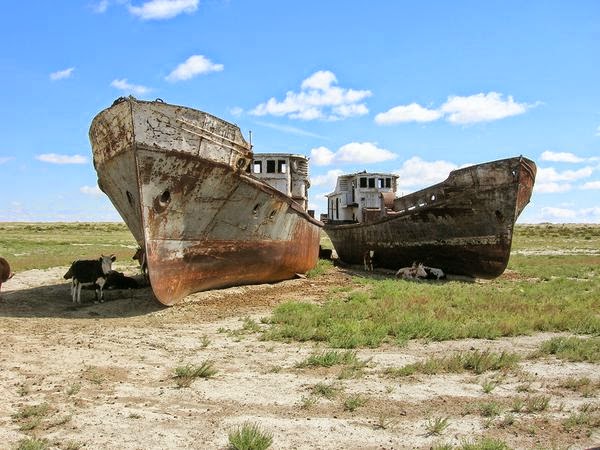
In the 1960s, Aral Sea was the fourth largest fishery in the Soviet Union. Ships like these brought in 50,000 tons of fish a year. But as the sea dried up, the ships were stranded.

As the salinity of the water increased, fish began to die, and most fishermen moved on. Quite a few rusty abandoned ships remain along the shores of the former Aral sad reminders of how quickly the industry collapsed.


Read more about the Aral Sea in National Geographic News.

Go to National Geographic Aral sea story

Wednesday, June 11, 2014

DESERTS OF CENTRAL ASIA


Photo : Deserts of Central Asia - Credit NASA
The satellite image above shows both the Kara Kum and Kyzyl Kum deserts. In addition the Aral Sea (upper left); and the delta of the Amu Darya (centre left). The Kyzil Kum lies to the east of the Amu Darya River and the Kara Kum to the west. These two great deserts of Central Asia the Kyzyl Kum (Red Sands) and the Kara Kum (Black Sands) for a long time served to isolate the interior of Asia due to the physical difficulty of traversing across such  unforgiving water-less plains.

Photo: Kyzyl Kum Desert

The Kyzyl Kum (aka Kizil Km, Kizylkum, Qizilqum, Қызылқум, etc.) is split between Kazakhstan and Uzbekistan.  It has an area of about 300,000 square km and lies between the Syr Darya and the Amu Darya (rivers), southeast of the Aral Sea. It consists of a plain sloping down toward the northwest, with a number of isolated bare mountains rising to 922 m and several large enclosed basins. Precipitation 100–200 mm annually, occurs mainly in winter and spring. Mostly it is covered with sand ridges on which many desert plants grow, these serve as pasture for Karakul sheep, horses, and camels. There are several small oasis settlements. Important natural-gas deposits and gold are also found within its territory.
Photo: Amu Darya
The Kyzyl Kum (Red Sand) desert, separated from the Kara Kum (Black Sand) desert by the waters of the Amu Darya River. Only a small part of the Kara Kum (aka Karakum, Garagum, Каракумы etc.) desert is in Uzbekistan, however it encompasses well over half the land area of Turkmenistan.
 Photo: Kara Kum Desert
The Karakum is approximately 350,000 sq km in area, extending some 800 km from west to east and 500 km from north to south. It is bordered on the north by the Sarykamysh Basin, on the northeast and east by the Amu Darya, and on the southeast by the Garabil uplands and Badkhyz steppe region. In the south and southwest the desert  runs along the foot of the Kopet-Dag mountains, and in the east and northwest it borders the course of the ancient valley of the Uzboy River.

Sources: http://www.britannica.com/EBchecked/topic/312099/Karakum-Desert and
http://www.britannica.com/EBchecked/topic/326177/Kyzylkum